Long-Range, Low-Power Data Links with the Radiometrix NTX2 modules
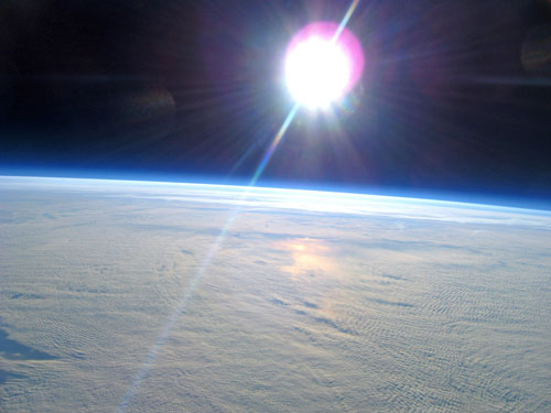
Cambridge University Spaceflight is a student group working to reduce the cost of access to space. Part of our mission involves making test flights on meteorological balloons to the “edge of space” at the top of the stratosphere. At altitudes in excess of 100,000 ft, the sky is black and the horizon is dramatically curved. Spectacular photographs such as the one below are taken by consumer digital cameras, and stored on memory cards on the payload platform. In order to recover them and other valuable hardware, we needed a data link capability to transmit GPS-derived position and other telemetry back to Earth.
Dedicated spectrum was outside of our budget range, and amateur radio licenses in the UK are not valid for unattended airborne operation. Thus, we needed a solution that would be compatible with the limited power allowed in the license-free bands. The 434MHz license-free band allows only 10mW (+10 dBm) EIRP, less than the light output by a single indicating LED. Nevertheless, we had to be able to reliably send data over distances up to 250km.
Radiometrix Ltd. have kindly supported us by providing several NTX2 modules. These compact, low-power UHF narrow-band transmitters are intended for use over ranges approaching 500 meters. To operate at the much longer distances we needed, a special approach was required.
Firstly, the data rate is decreased from the standard 9600 bps to 300 or 50 bps. This increases the noise margin by allowing the receiver to integrate over a longer bit period. Secondly, since the ground-station equipment does not have stringent mass and power requirements, we use a highly sensitive Yaesu FT-790R amateur radio receiver with a +13dBi Yagi directional receiving antenna. Thirdly, a tight 2.4 kHz single-sideband filter is selected on the receiver to further reject noise. The NTX2 is usually used with a logic-level digital input which results in a frequency-shift-keyed output with a peak deviation of 6 kHz. However, by using 1.0 V and 1.2 V to represent 0 and 1 instead of 0 V and 3 V, the deviation can be reduced to only 400 Hz, which fits within the receiver filter and is compatible with the RTTY standard. Open-source digital signal processing software (FLdigi) is then used to decode the audio-frequency downlink signal. The resulting data is passed to our flight-path prediction software and displayed graphically on Google Earth.
This approach to low-power, long-distance digital communication is simple, cheap and effective. The data rate can be further improved by sending one of several frequencies instead of just two (MFSK). We are experimenting with error-correcting codes and slow-scan television that will allow images to be transmitted during flight. We are also working on an uplink that will use similar techniques, with the additional constraint of <100g mass and <1W power consumption for the onboard receive equipment.
For more details including a wiki with schematics and code, please visit our website: http://www.cuspaceflight.co.uk/
Article by Henry Hallam, CU Spaceflight